


6759
460
947
 Français
Français
Français  English (AI)
  Deutsch (AI)
  Français
 English (AI) Deutsch (AI)
Français
Français English (AI) Deutsch (AI)
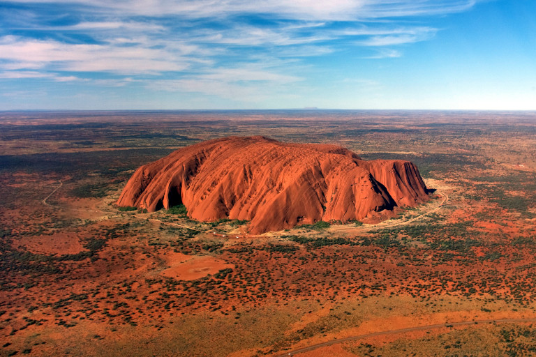
| Nom original | Uluru |
| Pays | Australie |
| Latitude | -25.344400 ▶ 25° 20′ 39.84″ S |
| Longitude | 131.036900 ▶ 131° 2′ 12.84″ E |
| Description | traduction/geologie/aus-uluru_fr.php |
| Lien Google images | https://www.google.com/search?q=Uluru&tbm=isch |
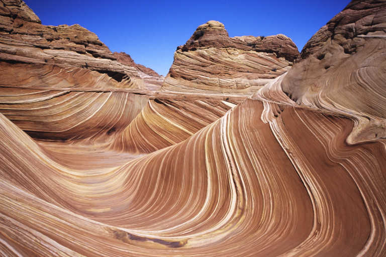
| Nom original | The Wave |
| Pays | États-Unis |
| Latitude | 36.996100 ▶ 36° 59′ 45.96″ N |
| Longitude | -112.006100 ▶ 112° 0′ 21.96″ W |
| Description | traduction/geologie/usa-the-wave_fr.php |
| Lien Google images | https://www.google.com/search?q=The+Wave+Arizona&tbm=isch |
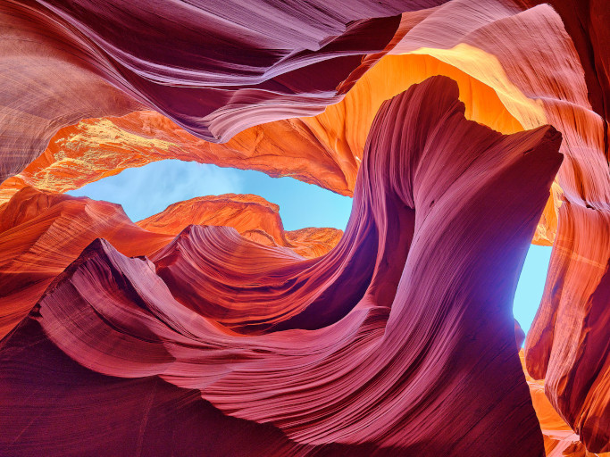
| Nom original | Antelope Canyon |
| Pays | États-Unis |
| Latitude | 36.861900 ▶ 36° 51′ 42.84″ N |
| Longitude | -111.374300 ▶ 111° 22′ 27.48″ W |
| Description | traduction/geologie/usa-antelope-canyon_fr.php |
| Lien Google images | https://www.google.com/search?q=Antelope+Canyon&tbm=isch |
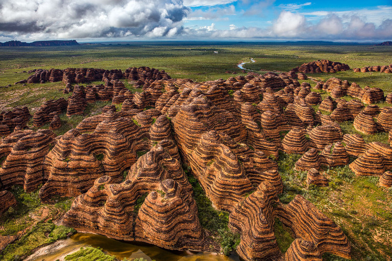
| Nom original | Bungle Bungle Range |
| Pays | Australie |
| Latitude | -17.483300 ▶ 17° 28′ 59.88″ S |
| Longitude | 128.300000 ▶ 128° 18′ 0.00″ E |
| Description | traduction/geologie/aus-bungle-bungle-range_fr.php |
| Lien Google images | https://www.google.com/search?q=Bungle+Bungle+Range&tbm=isch |
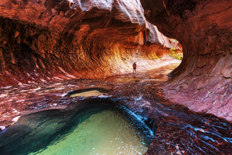
| Nom original | Zion Canyon |
| Pays | États-Unis |
| Latitude | 37.298200 ▶ 37° 17′ 53.52″ N |
| Longitude | -113.026300 ▶ 113° 1′ 34.68″ W |
| Description | traduction/geologie/usa-zion-canyon_fr.php |
| Lien Google images | https://www.google.com/search?q=Zion+Canyon&tbm=isch |
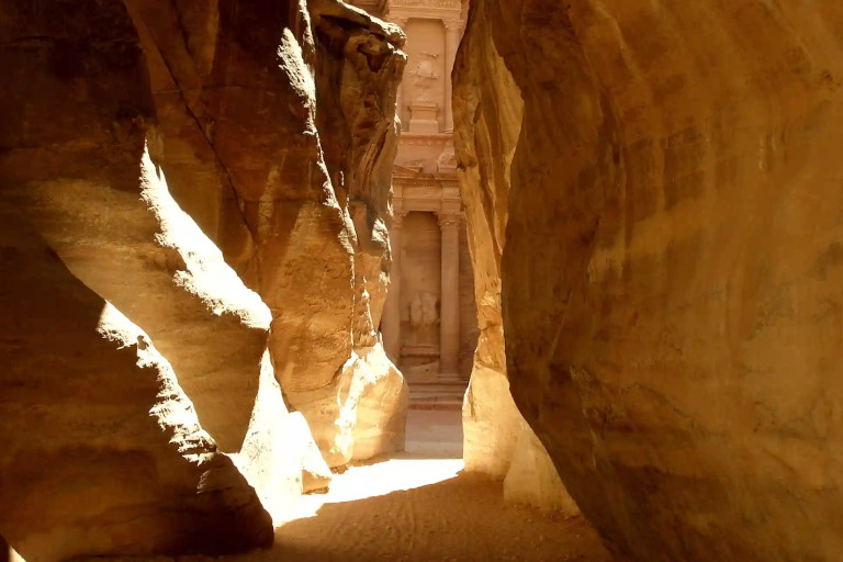
| Nom original | As-Siq |
| Pays | Jordanie |
| Latitude | 30.321600 ▶ 30° 19′ 17.76″ N |
| Longitude | 35.450000 ▶ 35° 27′ 0.00″ E |
| Description | traduction/geologie/jor-petra-siq_fr.php |
| Lien Google images | https://www.google.com/search?q=Petra+The+Siq&tbm=isch |
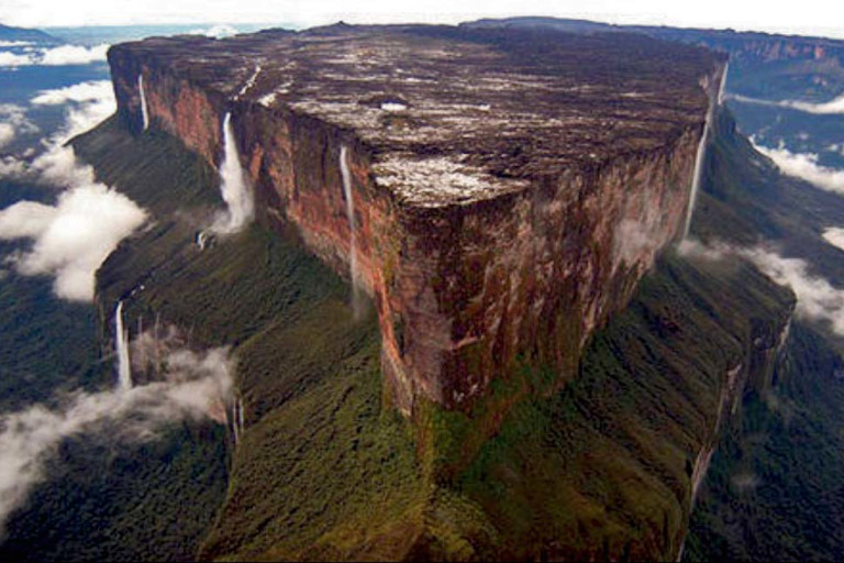
| Nom original | Mount Roraima |
| Pays | Venezuela |
| Latitude | 5.222200 ▶ 5° 13′ 19.92″ N |
| Longitude | -60.759400 ▶ 60° 45′ 33.84″ W |
| Description | traduction/geologie/ven-mont-roraima_fr.php |
| Lien Google images | https://www.google.com/search?q=Mount+Roraima+tepuy&tbm=isch |
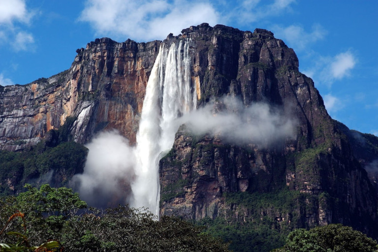
| Nom original | Salto Ángel |
| Pays | Venezuela |
| Latitude | 5.967500 ▶ 5° 58′ 3.00″ N |
| Longitude | -62.535600 ▶ 62° 32′ 8.16″ W |
| Description | traduction/geologie/ven-angel-falls_fr.php |
| Lien Google images | https://www.google.com/search?q=Auyan+Tepui+Angel+Falls&tbm=isch |
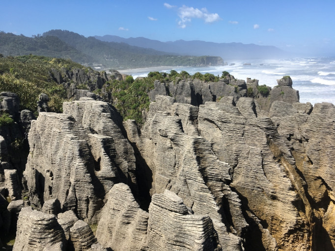
| Nom original | Punakaiki |
| Pays | Nouvelle-Zélande |
| Latitude | -42.115800 ▶ 42° 6′ 56.88″ S |
| Longitude | 171.328300 ▶ 171° 19′ 41.88″ E |
| Description | traduction/geologie/nzl-punakaiki_fr.php |
| Lien Google images | https://www.google.com/search?q=Punakaiki+Pancake+Rocks&tbm=isch |
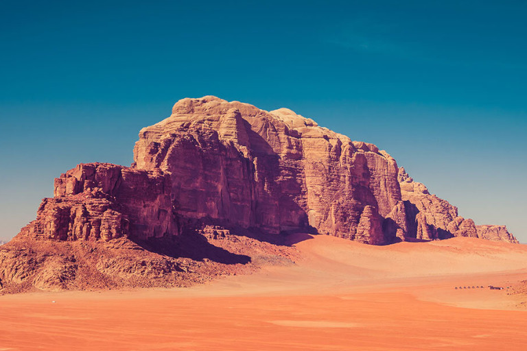
| Nom original | Wadi Rum |
| Pays | Jordanie |
| Latitude | 29.576100 ▶ 29° 34′ 33.96″ N |
| Longitude | 35.421100 ▶ 35° 25′ 15.96″ E |
| Description | traduction/geologie/jor-wadi-rum_fr.php |
| Lien Google images | https://www.google.com/search?q=Wadi+Rum+Jordan&tbm=isch |
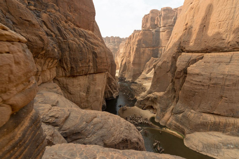
| Nom original | Guelta d'Archei |
| Pays | Tchad |
| Latitude | 16.903100 ▶ 16° 54′ 11.16″ N |
| Longitude | 21.771900 ▶ 21° 46′ 18.84″ E |
| Description | traduction/geologie/tcd-guelta-archei_fr.php |
| Lien Google images | https://www.google.com/search?q=Guelta+d'Archei+Chad&tbm=isch |
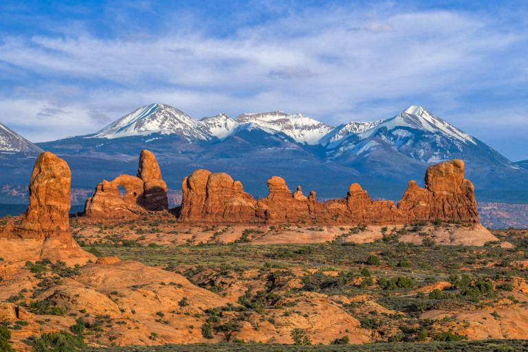
| Nom original | La Sal Mountains |
| Pays | États-Unis |
| Latitude | 38.449200 ▶ 38° 26′ 57.12″ N |
| Longitude | -109.243600 ▶ 109° 14′ 36.96″ W |
| Description | traduction/geologie/usa-montagnes-la-sal_fr.php |
| Lien Google images | https://www.google.com/search?q=La+Sal+Mountains+Arches+National+Park&tbm=isch |
| Nom original | Syrnaya Skala |
| Pays | Russie |
| Latitude | 44.755600 ▶ 44° 45′ 20.16″ N |
| Longitude | 34.444700 ▶ 34° 26′ 40.92″ E |
| Description | traduction/geologie/_fr.php |
| Lien Google images | https://www.google.com/search?q=Cheese+Rocks+Crimea&tbm=isch |
| Nom original | Reinebringen |
| Pays | Norvège |
| Latitude | 67.927500 ▶ 67° 55′ 39.00″ N |
| Longitude | 13.085600 ▶ 13° 5′ 8.16″ E |
| Description | traduction/geologie/_fr.php |
| Lien Google images | https://www.google.com/search?q=Lofoten+islands+landscape&tbm=isch |
| Nom original | Factory Butte |
| Pays | États-Unis |
| Latitude | 38.436900 ▶ 38° 26′ 12.84″ N |
| Longitude | -110.913600 ▶ 110° 54′ 48.96″ W |
| Description | traduction/geologie/_fr.php |
| Lien Google images | https://www.google.com/search?q=Factory+Butte+Utah&tbm=isch |
| Nom original | Fire Wave |
| Pays | États-Unis |
| Latitude | 36.488300 ▶ 36° 29′ 17.88″ N |
| Longitude | -114.528900 ▶ 114° 31′ 44.04″ W |
| Description | traduction/geologie/_fr.php |
| Lien Google images | https://www.google.com/search?q=Fire+Wave+Valley+of+Fire&tbm=isch |
| Nom original | Spitzkoppe |
| Pays | Namibie |
| Latitude | -21.825000 ▶ 21° 49′ 30.00″ S |
| Longitude | 15.166700 ▶ 15° 10′ 0.12″ E |
| Description | traduction/geologie/_fr.php |
| Lien Google images | https://www.google.com/search?q=Spitzkoppe+Namibia&tbm=isch |
| Nom original | Reflection Canyon |
| Pays | États-Unis |
| Latitude | 37.185600 ▶ 37° 11′ 8.16″ N |
| Longitude | -110.920000 ▶ 110° 55′ 12.00″ W |
| Description | traduction/geologie/_fr.php |
| Lien Google images | https://www.google.com/search?q=Reflection+Canyon+Lake+Powell&tbm=isch |
| Nom original | Khao Sok |
| Pays | Thaïlande |
| Latitude | 8.916700 ▶ 8° 55′ 0.12″ N |
| Longitude | 98.533300 ▶ 98° 31′ 59.88″ E |
| Description | traduction/geologie/_fr.php |
| Lien Google images | https://www.google.com/search?q=Khao+Sok+National+Park+lake&tbm=isch |